
")
")
")

Provided Services
![]() Environments Sanitized with OZONE
Environments Sanitized with OZONE
![]() Free Internet Wi-Fi
Free Internet Wi-Fi
![]() Heated swimming pool
Heated swimming pool
![]() Lawn chairs
Lawn chairs
![]() Children’s playground
Children’s playground
![]() Covered parking
Covered parking
![]() Covered storage for bicycles, motorcycles and sports equipment
Covered storage for bicycles, motorcycles and sports equipment
![]() Gym
Gym
![]() Satellite TV
Satellite TV
![]() Dishes & Utensils
Dishes & Utensils
![]() Laundry
Laundry
![]() Barbecue
Barbecue
Car and Scooter Rental in Malcesine

Directly in front of Casa Guarnati Holiday Apartments you will find a Car and Scooter rental to live your holiday on Lake Garda at best!
Rent Now a Car or Scooter in Malcesine
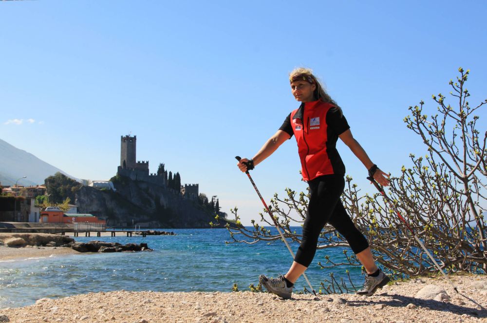
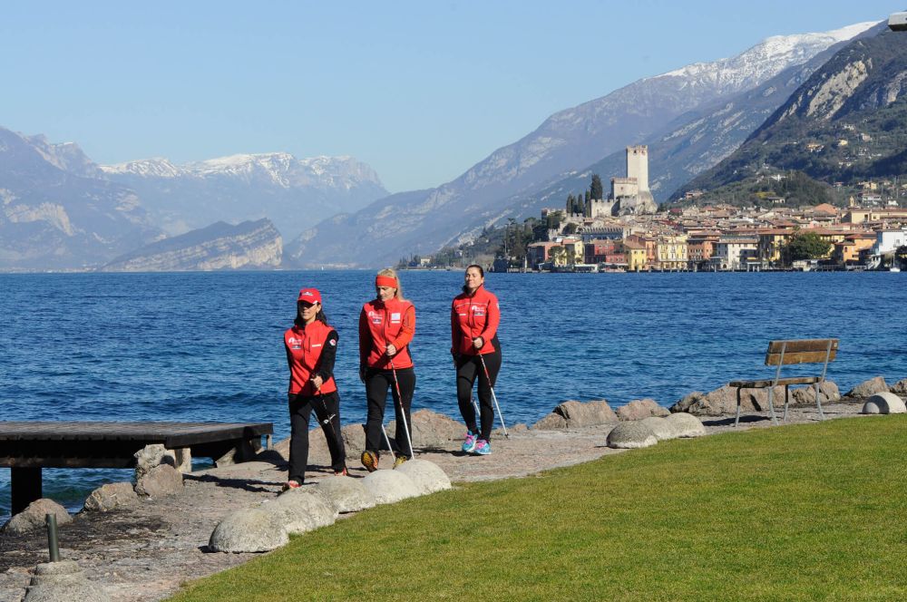
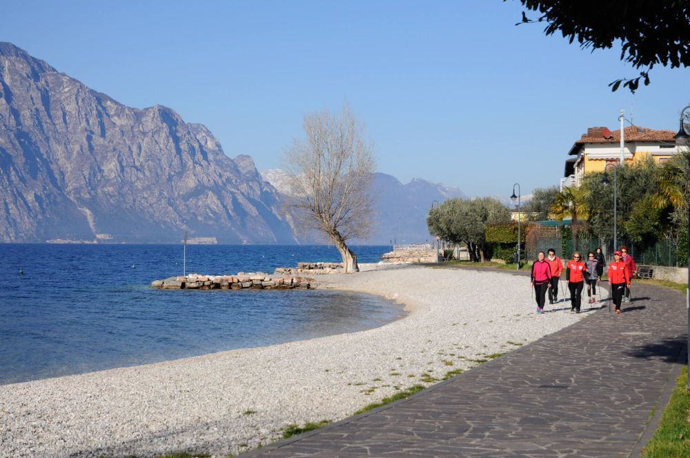
Nordic Walking in Malcesine and on Monte Baldo
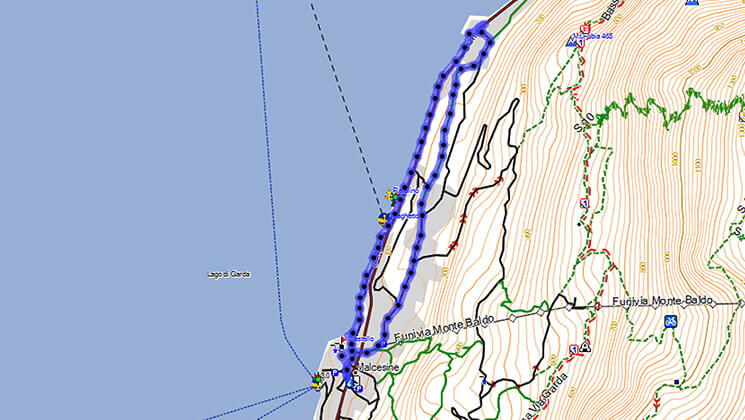
GPS Maps and Tracks for Nordic Walking in Malcesine
GPS tracks in GDB format are available for you to organize excursions in the area of Malcesine and Monte Baldo.
Nordic Walking Malcesine
- Ring no. 1: Campagnola (Malcesine)
- Ring no. 1 A: Sotto Dossi (Malcesine)
- Ring no. 2: Madonna Accoglienza (Malcesine)
- Ring no. 3 A: San Maggiore (Malcesine)
- Ring no. 4: Navene - Val Bova (Malcesine)
- Ring no. 5: Malcesine - Cassone (ciclopedonale)
- Ring no. 5 A: 2 towns (Malcesine - Brenzone)
- Ring no. 6 B: Connection Ring no. 4 (Malcesine - Navene)
- Ring no. 7: San Michele - Faigolo (Malcesine)
- Excursion Ring no. 7: San Michele - Faigolo (Malcesine)
Nordic Walking Maps Monte Baldo
- Ring no. 8: Colma (Monte Baldo)
- Ring no. 9: Tratto Spino (Monte Baldo)
- Ring no. 10: Malghe Tour (Monte Baldo)
- Ring no. 10 B: Malghe Tour with return from Valletta (Monte Baldo)
- Ring no. 11: Omini (Monte Baldo)
DIFFICULTY LEVEL
A - light blue = easy
R - red = hard
N - black = very hard
E - excursion
Nordic Walking Maps in Malcesine
Km 6,1
Climb 63 mt
Difficulty A
The route runs in the inside areas of Malcesine among wide and ancient olive tree gardens to reach the site of Campagnola.
Flanking the lake, it gets back passing near the paragliding landing area, at the ferries’ dock, to reach the town passing under the Castle.
In some stretches, it flanks the Navene Vecchia road and the Gardesana road.
Track Download
Malcesine - Campagnola
Km 3,6
Climb 35 mt
Difficulty A
Short route ring 1 Campagnola. The short route of the Campagnola ring brings you to the site of Sotto Dossi going through a little dirt road among olive trees.
Track Download

Sotto Dossi - Malcesine
Km 6,4
Climb 329 mt
Difficulty R
This route lets you discover the areas surrounding Malcesine, along mule tracks, paths and olive tree areas to reach and visit the Madonna dell’Accoglienza site. In some stretches, you flank the asphalted road, Navene Vecchia, Gardesana and Panoramica. In some sections of the route, it is not possible to use the nordic walking technique
Track Download

Malcesine - Madonna dell'Accoglienza
Km 2,5
Climb 151 mt
Difficulty A / R
Percorso corto n° 1 Campagnola
The Ring San Maggiore Calchere site is located in the upper area of Malcesine, at about 300/400 metres of height.
This route follows paths and asphalted road stretches among black pine, black hornbeam and ash tree woods and the farmhouses of various villages.
In some stretches of the route, it is not possible to use the nordic walking technique.
Track Download
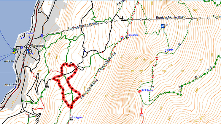
San Maggiore (Malcesine)
Km 3,6
Climb 137 mt
Difficulty R
The route follows military roads, paths and a stretch of asphalted road and gets you along the Val dell’Acqua (Water Valley) and the Val Bova within a holm oak woodland. In some stretches of this route, it is not possible to use the nordic walking technique.
Track Download
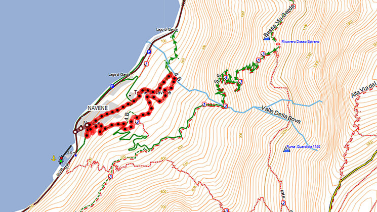
Navene - Malcesine
Km 4,3
Climb 27 mt
Difficulty F
The route links Malcesine to Cassone and with the ring 5B to the Nordic Walking Park of the town of Brenzone.
It enables you to discover all the special places that characterize our town, its little roads, the small ports, the lakeshore, the Val di Sogno Bay, the olive-tree island.
Track Download
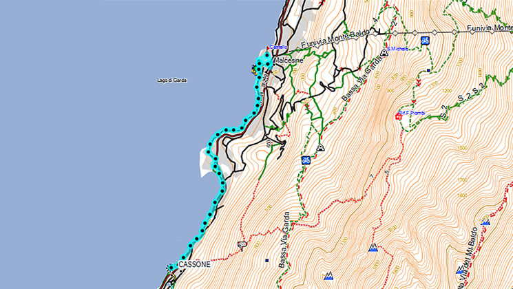
Malcesine - Cassone
Km 3,3
Climb 91 mt
Difficulty A / R
This route gets you to discover the fish museum in Cassone, and then goes into the inland along mule tracks and paths, to reach some little villages between Malcesine and Brenzone.
Along this route, you can enjoy an amazing view of the Trimelone Island, in front of Assenza. A stretch runs along the S. Nicola ring of the nordic walking park of Brenzone.
In some stretches of the route, it is not possible to use the nordic walking technique.
Track Download
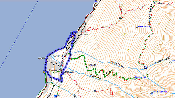
Malcesine - Brenzone
Km 5,1
Climb 37 mt
Difficulty A
Connection nr. 4 Navene - Val Bova
This route follows the lake with its bays and beaches along the bike lane and links Malcesine to Navene, a little town to the North.
Track Download
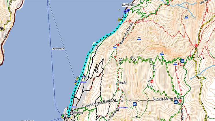
Malcesine - Navene
Km 5
Climb 236 mt
Difficulty R
A route around the middle stop of Monte Baldo cable car, that through paths, dirt roads and, for a stretch, along the Panoramic road, gets you to the last farmhouses of the little town of Faigolo and to the surroundings of San Michele, with its little church in the middle of a pinewood.
In some stretches of the route, it is not possible to use the nordic walking technique.
Track Download

San Michele - Faigolo
Km 5,4
Climb 270 mt
Difficulty E
Parallel to the Faigolo dirt road, this is considered an excursion path (E) with amazing views of the lake, but not suitable for the nordic walking technique.
Track Download
San Michele - Faigolo
Mappe Nordic Walking Maps Monte Baldo
Km 6,1
Climb 63 mt
Difficulty A
A fairly simple route on the Colma of Monte Baldo where you can see a 360-degree view from the Presanella and the Adamello glaciers to the Pre-Alps of Brescia, Trentino and Veneto, the Brenta group, the Pasubio and the Carega and appreciate the impressive beauty of Lake Garda.
In some stretches of the route, it is not possible to use the nordic walking technique.
Track Download

Colma
Km 2,1
Climb 92 mt
Difficulty R
This route can be an extension of the Colma ring.
It follows dirt roads and a linking stretch of grazing lands.
In some parts of the route, it is not possible to use the nordic walking technique.
Track Download

Tratto Spino
Km 8,3
Climb 116 mt
Difficulty R
A tour that crosses the grazing lands of 4 mountain huts, goes into secular beech forests and follows dirt roads, paths and stretches of asphalted road (Graziani road).
At Pra Alpesina it goes up with with the cable car and then gets back to Tratto Spino from the high side of Monte Baldo.
In some parts of the route and on the ascent or descent connection to or from Tratto Spino it is not possible to use the nordic walking technique.
Track Download

Malghe
Km 7,1
Climb 437 mt
Difficulty E
The route is the same of the Malghe Tour with return on foot at the arrival of the cable car from the Valletta path.
On the ascent or descent connection to or fromTratto Spino (A – B) it is not possible to use the nordic walking technique.
Track Download
Malghe
Km 4,9
Climb 159 mt
Difficulty R / E
A highly panoramic route that gets you near the first peaks of the Baldo mountain chain.
In bright days, if you look to the South, you can see the highest tops of the Appennines, Mount Blanc, Mount Rosa, Cervino.
It follows a dirt road and a mountain path.
For a stretch along the peaks route, it passes through the nature reserve Lastoni Selva Pezzi, where it is possible to see Chamois and Eagles.
Along this path, it is not possible to use the nordic walking technique.
Track Download

Omini
Provided Services
![]() Environments Sanitized with OZONE
Environments Sanitized with OZONE
![]() Free Internet Wi-Fi
Free Internet Wi-Fi
![]() Heated swimming pool
Heated swimming pool
![]() Lawn chairs
Lawn chairs
![]() Children’s playground
Children’s playground
![]() Covered parking
Covered parking
![]() Covered storage for bicycles, motorcycles and sports equipment
Covered storage for bicycles, motorcycles and sports equipment
![]() Gym
Gym
![]() Satellite TV
Satellite TV
![]() Dishes & Utensils
Dishes & Utensils
![]() Laundry
Laundry
![]() Barbecue
Barbecue
Car and Scooter Rental in Malcesine
Directly in front of Casa Guarnati Holiday Apartments you will find a Car and Scooter rental to live your holiday on Lake Garda at best!
Rent Now a Car or Scooter in Malcesine

Casa Guarnati
Holiday Apartments Malcesine Lake Garda
Via Gardesana 310
37018 Malcesine VR - Italy
Tel:
+39 339 80 35 256
+39 348 72 01 913
Website: www.casaguarnati.com
E-mail: This email address is being protected from spambots. You need JavaScript enabled to view it.
VAT 02649230238
Tarifs: €80 - €280